CARI Infonet

Title: Keindahan Pulau Surga Dunia, Gunung Di Lautan Ball's Pyramid (21 photos +2 video [Print this page]

Author: abgsedapmalam    Time: 21-5-2012 02:38 PM
Title: Keindahan Pulau Surga Dunia, Gunung Di Lautan Ball's Pyramid (21 photos +2 video
Ball's Pyramid   Yesterday we looked at two pebble in the ocean.  A stone with a cap , and another stone with oil .  Let us now look at the stone SAIL.


  Clickable 1200 px


  Ball's Pyramid (English Ball's Pyramid, 31 ° 45'21 "w. W. 159 ° 15'02" to. Etc.) - a small volcanic island in the Tasman Sea, 20km south-east of Lord Howe Island .  Known, which is the highest volcanic rock on the planet (562m.).  The island is uninhabited and looks like a huge sail.


  The island was discovered in 1788, the first man landed on it much later - in 1882.  There are currently visiting the island is strictly regulated and requires permission not only to guide Lord Howe Island, to which Ball's Pyramid is geographically, but also directly to the Australian Government.  In short, get on it is almost impossible and can only admire this vast object stone from a distance, from the board any recreational vessel.
  Another interesting fact: in 2000.  on this island was discovered by a small colony (about 30 individuals) Giant stick insects - insects relic that has long been thought to be extinct.  The only question is whether people save the last of this kind ...

  The area of ​​its base - a total of 200 square meters.  meters.  But the height - 562 meters.  Bols Pyramid lies between Australia and New Zealand, but tourists do not spoil the attention that high-altitude vista of the Pacific.  There's really no place to build hotels, no beach.  Even the conquest of the peak of 1982 prohibits local authorities.
  Prior to the ban is still some good climbing climbers had to make.  But since 1986, not only the ascent - limited even just visiting the cliff.


  The exception was the expedition of scientists who have studied the local fauna and flora.  Yes, the stones of the Pyramids Bols is not lifeless, as it might at first seem.  Oozing moisture between the stones provides power to small shrubs.  And those, in turn, otmiraya create blockages brushwood.  That that's the brushwood, and biologists expect the biggest surprise - they found a small population of the insect Dryococelus australis - a giant stick insects.  But it was thought that he was dead.  A couple of stick insects were sent to the zoo - to reproduce.


  Even the rocks of the island without interest.  Rock - a volcanic origin, and it is believed that its submarine base - Tasmanian continent, a huge recessed plateau, whose apex - New Zealand and all the islands in this region.  You can imagine how high Bols Pyramid is not above sea level, but from its inception - Tasmanian plateau of the continent!


  Ball's Pyramid located next to another interesting island


  Lord Howe (born Lord Howe Island) - a small volcanic island shaped like a boomerang, stretched from north to south for 10 miles and has a width of about 2 km.  Coordinates - 31 ° 45'21 "w.  sh.  159 ° 15'02 "to.  Belongs on Australia (part of the State of New South Wales).
  It has internal self-government.  Located in the Tasman Sea, 770 kilometers north-east of Sydney (Australia), and approximately 1,200 kilometers to the southwest of the island of New Caledonia (overseas territory of France).  The island is located about midway between the continental coast of Australia and Norfolk Island belonging to it.  The area of Lord Howe Island - 14.6 km ².  Resident population - 300-350 people, while on the island are allowed to remain for another 400 tourists.


  Lord Howe Island is shaped like a boomerang 10x2 km in the Tasman Sea, quite remote from the mainland (about 770 kilometers from Sydney

  Clickable 1400 px   Location of Lord Howe Island
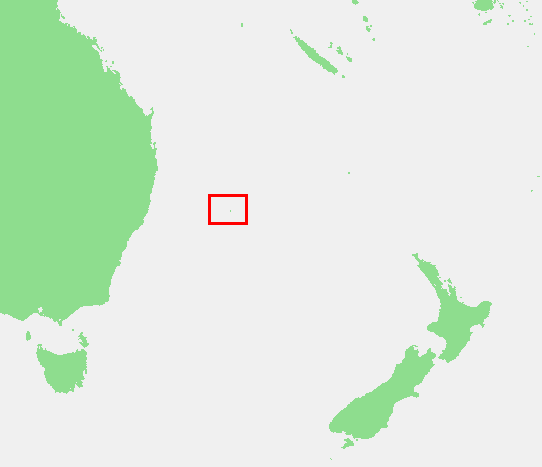

  Age Lord Howe Island - about 20 million years, making it one of the oldest volcanic islands in the Pacific.  The northern and southern islands are of volcanic origin, and the central part consists of packed coral sand.  Thus, Lord Howe is the result of the merger of two volcanic islands.  The area corresponding to the north are mostly occupied by hills and low mountains (up to 300 m above sea level).  In the southern part of Lord Howe are two basalt mountain ranges - Lidgberd (650 m or 777 m) and Hoover (757 m or 875 m).  Coral bridge is covered with dunes up to 45 m significant part of the bay, washing the island from the west, is occupied by a coral reef.  Between him and poberezheem Lord Howe is a small island of coral origin Rabbit.  Coastal waters of Lord Howe - the southernmost point on Earth, where there are colonies of coral polyps.

  Clickable 3500 px
Author: abgsedapmalam    Time: 21-5-2012 02:41 PM
Post Last Edit by abgsedapmalam at 21-5-2012 15:05

Lord Howe is on the boundary of the tropical and subtropical climatic zones.  The temperature and lighting conditions on the island are critical for the development of woody vegetation in the Southern Hemisphere.  There is a pronounced differentiation of the vegetation between the convex and concave slopes.  A significant part of the island is covered by tropical forests, which are both single deck and bunk.  Describes 209 species of higher plants, of which 70 are endemic to Lord Howe.

  Lord Howe Island was opened on February 17, 1788 a British ship under the command of Lieutenant Lidgberda, sailing with the prisoners on board from Australia to Norfolk Island.  The first settlers arrived on the island of New Zealand in 1834, the beginning of XX century there were the first tourists.  Today's economy based on tourism.  Also, the export of seeds of endemic palms Howea forsteriana (born kentia palm), widely used as an ornamental plant.


In the 16-25 km south-east of Lord Howe is the tiny islet of Ball's Pyramid.  Its length - 200 m and the highest point - 562 m (or 650 m).  Ball's Pyramid Island was discovered, along with Lord Howe in 1788 and administratively belongs to him.

Along almost the entire western coast of the island is a coral reef.  Incidentally, the coast of Lord Howe is the southernmost habitat of coral on the planet


  There are even some wonderful fluorescent corals


  70 out of more than 200 species of plants growing on the island are unique and found only here


  Here is a wonderful place!

[youtube]BdjVTkUBBe0[/youtube]


[youtube]NzfLwQkM9LU[/youtube]


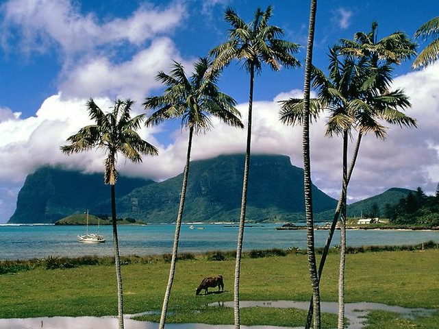
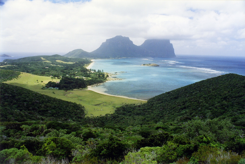
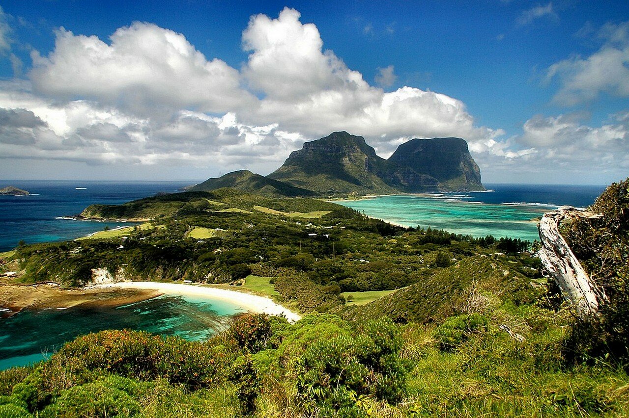
Australian Island paradise located about a two hour flight from Sydney, Australia. Travel documentary by Robert Stephens. Thanks to Ian Hutton and Marie Stephens for appearing on screen, and to David Berkman and Jack Shick for lending their photographs. Filmed on Lord Howe Island in March 2010.

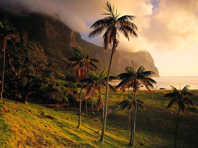
Lord Howe Island is a truly unique travel destination for anyone to visit. Visitor numbers are limited to 400. There are about 320 islanders.

The Lord Howe Woodhen, also called the Lord Howe Rail, is a small bird of the rail family. The Lord Howe Woodhen is flightless. The species is endemic to Lord Howe Island off of Australia.

Lord Howe Woodhens have dull brownish-olive plumage, and can be identified by their short tails and long, down-curved bills.

Filmed, written and edited by Robert Stephens. Voiceovers by Robert Stephens. Edited in Final Cut Pro with LiveType. Canon 5D Mark2 and Canon Vixia HV40. Miller Monopod. Manfrotto tripod. Tags: Lord Howe Island, White Terns, White tern, Black Noddy, Black Noddies, Island naturalist Iam Hutton, Mount Gower hike led by Jack Shick, Mount Lidgbird, Ned's Beach, World's Southernmost coral reef, Lagoon swimming off pontoon, Arajilla retreat hotel, Arajilla restaurant, bikes, hikers, Blinkey Beach, Clear Place, Ball's Pyramid, Lord Howe Island Phasmid or flightless stick insect, North Bay, Woodhen recovery program, Ian Hutton tours, Jack Shick hikes, surfer girls, beautiful island paradise, honeymoon island, beautiful sunrises, stunning beauty, quiet, return to childhood, large turtle swimming off Old Settlement Beach, Mount Gower summit photograph, Kentia palm, photo from Lord Howe Island Museum, thatched palm, Norfolk pine, Nofolk pines, Lord Howe vista, high definition, Lord Howe Hi Def video, best quality travel video, vacation in Australia, volcanic island, spectacular scenery, beautiful beaches, locally caught kingfish, unlocked doors, Norfolk pines, Sea to Summit Expeditions, QantasLink flies from Sydney to Lord Howe, companion film to Lord Howe Island: Paradise Found, follow-up film to Lord Howe Island: Paradise Found, Oprah Australia, Ball's Pyramid at Lord Howe Is., NSW, New South Wales, lord howe island surfing, travel documentaries australia, beautiful australian scenery, lord howe island last paradise, australian island

http://ms.wikipedia.org/wiki/Pulau_Lord_Howe

Author: lonso    Time: 21-5-2012 02:49 PM
siyes cantikkkkkkkkkk
Author: novelloverzz    Time: 21-5-2012 03:16 PM
cantik sgt..
Author: yusryimran    Time: 21-5-2012 04:08 PM
sangat cantik pulau ini
Author: sapp73    Time: 21-5-2012 04:13 PM
ya allah...cantiknya.
Author: Artemesiaa    Time: 21-5-2012 06:22 PM
Wow really myzig
Author: menjad    Time: 21-5-2012 07:32 PM
coral nyer timbul ek!...cantik betul!
Author: HaMiZiE    Time: 21-5-2012 11:09 PM
What A viewwwwwww....
Memang cantikkkkk
Author: ctaz    Time: 22-5-2012 11:19 AM
perghhhh....dpt tgk gambo jer la.....
Author: izumiza    Time: 22-5-2012 11:33 AM
cantiknya
Author: alphawolf    Time: 22-5-2012 11:42 AM
Tak secantik Bora-Bora....

Ball's Pyramid tu pulak syurga rock climber
Author: ratuiphone    Time: 22-5-2012 01:33 PM
tak penah pegi aussie..tgk gambar pun okay larr
Author: mrsT    Time: 22-5-2012 01:40 PM
sangattt cantikk..
Author: shiraloveyou    Time: 24-5-2012 11:04 AM
wahhhh cantiknyeeee...nmpak tenang sgt
Author: MengkuduMasam    Time: 24-5-2012 11:37 AM
aku takut kalo coral kaler2 nih.. creepy smacam jah...
Author: cmf_lemontea    Time: 24-5-2012 11:57 AM
sgt cantik................


Welcome to CARI Infonet (https://mforum.cari.com.my/) Powered by Discuz! X3.4