Hari ini dalam sejarah.
Tarikh Peristiwa: 11.12.1999
Pada hari ini dalam tahun 1999, Syed Razak bin Syed Zain Barakhbah telah mengangkat sumpah memegang jawatan sebagai Menteri Besar Kedah di hadapan Sultan Kedah di Istana Anak Bukit. Beliau dilantik sebagai Menteri Besar Kedah ke-8 dan bertanggungjawab menjalankan urusan pentadbiran negeri Kedah serta berusaha memajukannya selaras dengan amanah yang telah dipertanggungjawabkan oleh Sultan Kedah ke-27 Sultan Abdul Halim Shah. Majlis yang diadakan pada hari ini turut dihadiri oleh Yang Dipertua Majlis Agama Islam Kedah (MAIK), Datuk Yahaya Jusoh, Hakim Mahkamah Tinggi, Datuk Alauddin Mohd Sheriff, bekas Menteri Besar Kedah, Tan Sri Osman Aroff, Ahli Majlis Mesyuarat Kerajaan Negeri (Exco) dan Ahli Dewan Undangan Negeri (Adun) dari Barisan Nasional (BN) dan Pas. Beliau telah menjawat jawatan sebagai Menteri Besar Kedah selama 6 tahun bermula dari tahun 1999 sehingga tahun 2005. Pada bulan Disember tahun 2005 beliau telah mengundurkan diri dari menjawat jawatan Menteri Besar Kedah setelah mengalami masalah kesihatan yang serius. Sepanjang pentadbiran beliau sebagai Menteri Besar Kedah pelbagai peristiwa menarik telah berlaku antaranya ialah penaiktarafan Alor Setar menjadi sebuah bandaraya pada usia Alor Setar 263 tahun dan juga bencana tsunami yang banyak membawa kemusnahan kepada negeri Kedah telah berlaku. Kini beliau tetap dikenang oleh rakyat Negeri Kedah sebagai salah seorang tokoh yang berjasa dalam kemakmuran negeri Kedah.
Dato' Seri Syed Razak dilantik sebagaiMenteri Besar Kedah ke-8 menggantikan Tan Sri Dato' Seri Sanusi Junid pada 12 Disember 1999 sehingga 2005. Sebagai Menteri Besar Kedah pada masa itu beliau bertanggungjawab ke atas kewangan dan belanjawan negeri, bertindak sebagai Pengerusi Jawatankuasa Galakan Pelaburan, Jawatankuasa Perancang Ekonomi Negeri, Jawatankuasa Perancang Negeri, Majlis Pembangunan Negeri, Jawatankuasa Tanah dan Hasil Bumi, Jawatankuasa Pembangunan Teknologi Maklumat dan Jawatankuasa Keselamatan Negeri.
Beliau diganti oleh Datuk Seri Mahdzir Khalid
Dato' Seri Syed Razak dilahirkan pada 22 Ogos 1944, di Kubang Rotan, Kuala Kedah. Beliau mendapat pendidikan menengah di Sekolah Menengah St. Michael, Alor Setar, Kedah.
Dato' Seri Syed Razak merupakan seorang usahawan bumiputera yang berjaya di dalam bidang perniagaan. Kejayaan beliau boleh dianggap setanding dengan usahawan-usahawan bukan Melayu. Kewibawaan beliau dalam bidang perniagaan menyebabkan beliau diberi kepercayaan menerajui Dewan Perniagaan dan Perusahaan Melayu Malaysia Cawangan Kedah (DPPMMK) sejak tahun 1986 lagi. Menerusi Dewan Perniagaan dan Perusahaan Melayu Malaysia Cawangan Kedah (DPPMMK), Dato' Seri Syed Razak cuba sedaya upaya untuk membawa peniaga-peniaga Bumiputera ke arah masyarakat perdagangan dan perindustrian sejajar dengan matlamat Wawasan 2020 untuk menjadikanMalaysia sebagai sebuah negara maju.
Bagi menghargai sumbangan dan jasa baktinya beliau telah dianugerahi pingat dan darjah kebesaran iaitu,
1. Seri Setia Di Raja Kedah (S.S.D.K.),
2. Kesatria Mangku Negara (K.M.N.),
3. Bintang Kebaktian Masyarakat (B.K.M.),
4. Jaksa Pendamai (J.P.)
Gambar YAB Dato Seri Syed Razak Syed Zain Barakhbah sedang berucap semasa menjadi Menteri Besar
Pada hari dalam tahun 1981, Dewan Negara telah meluluskan Rang Undang-Undang Waktu Standard Malaysia. Rang Undang-undang ini adalah bertujuan untuk menyelaraskan zon waktu antara Semenanjung Malaysia dengan Sabah dan Sarawak yang akan berkuatkuasa mulai 1 Januari 1982. Rang Undang-undang Waktu Standard Malaysia ini dikemukakan untuk bacaan kali kedua oleh Menteri Tak Berpotfolio di Jabatan Perdana Menteri, Datuk Haji Mohamed Nasir. Seramai sepuluh orang senator termasuk dari Sabah dan Sarawak telah mengambil bahagian dalam perbahasan rang undang-undang ini. Datuk Mohamed ketika mengemukakan rang undang-undang tersebut menyatakan bahawa waktu Sabah dan Sarawak dipilih sebagai waktu Standard Malaysia kerana ia didapati paling sesuai dari segi penjimatan ke atas waktu siang. Waktu ini akan hanya mendatangkan gangguan yang minima ke atas keselesaan dan kebiasaan hidup rakyat pada keseluruhannya. Rang Undang-undang Waktu Standard Malaysia yang diluluskan oleh Dewan Rakyat pada hari ini dalam tahun 1981 sesungguhnya dapat mempercepatkan usaha kerajaan melaksanakan program intergrasi nasional antara penduduk-penduduk di Semenanjung Malaysia dengan Sabah dan Sarawak.
The 13th Amendment is formally adopted into the U.S. Constitution, ensuring that “neither slavery nor involuntary servitude… shall exist within the United States, or any place subject to their jurisdiction.”
Following its ratification by the requisite three-quarters of the states earlier in the month, the 13th Amendment is formally adopted into the U.S. Constitution.
Before the American Civil War, Abraham Lincoln and other leaders of the anti-slavery Republican Party sought not to abolish slavery but merely to stop its extension into new territories and states in the American West. This policy was unacceptable to most Southern politicians, who believed that the growth of free states would turn the U.S. power structure irrevocably against them. In November 1860, Lincoln’s election as president signaled the secession of seven Southern states and the formation of the Confederate States of America. Shortly after his inauguration in 1861, the Civil War began. Four more Southern states joined the Confederacy, while four border slave states in the upper South remained in the Union.
Lincoln, though he privately detested slavery, responded cautiously to the call by abolitionists for emancipation of all American slaves after the outbreak of the Civil War. As the war dragged on, however, the Republican-dominated federal government began to realize the strategic advantages of emancipation: The liberation of slaves would weaken the Confederacy by depriving it of a major portion of its labor force, which would in turn strengthen the Union by producing an influx of manpower. With 11 Southern states seceded from the Union, there were few pro-slavery congressmen to stand in the way of such an action.
In 1862, Congress annulled the fugitive slave laws, prohibited slavery in the U.S. territories, and authorized Lincoln to employ freed slaves in the army. Following the major Union victory at the Battle of Antietam in September, Lincoln issued a warning of his intent to issue an emancipation proclamation for all states still in rebellion on New Year’s Day.
That day–January 1, 1863–President Lincoln formally issued the Emancipation Proclamation, calling on the Union army to liberate all slaves in states still in rebellion as “an act of justice, warranted by the Constitution, upon military necessity.” These three million slaves were declared to be “then, thenceforward, and forever free.” The proclamation exempted the border slave states that remained in the Union and all or parts of three Confederate states controlled by the Union army.
The Emancipation Proclamation transformed the Civil War from a war against secession into a war for “a new birth of freedom,” as Lincoln stated in his Gettysburg Address in 1863. This ideological change discouraged the intervention of France or England on the Confederacy’s behalf and enabled the Union to enlist the 180,000 African American soldiers and sailors who volunteered to fight between January 1, 1863, and the conclusion of the war.
As the Confederacy staggered toward defeat, Lincoln realized that the Emancipation Proclamation, a war measure, might have little constitutional authority once the war was over. The Republican Party subsequently introduced the 13th Amendment into Congress, and in April 1864 the necessary two-thirds of the overwhelmingly Republican Senate passed the amendment. However, the House of Representatives, featuring a higher proportion of Democrats, did not pass the amendment by a two-thirds majority until January 1865, three months before Confederate General Robert E. Lee’s surrender at Appomattox.
On December 2, 1865, Alabama became the 27th state to ratify the 13th Amendment, thus giving it the requisite three-fourths majority of states’ approval necessary to make it the law of the land. Alabama, a former Confederate state, was forced to ratify the amendment as a condition for re-admission into the Union. On December 18, the 13th Amendment was officially adopted into the Constitution–246 years after the first shipload of captive Africans landed at Jamestown, Virginia, and were bought as slaves.
Slavery’s legacy and efforts to overcome it remained a central issue in U.S. politics for more than a century, particularly during the post-Civil War Reconstruction era and the African American civil rights movement of the 1950s and ’60s
I ingat ni tau! I kecik masa ni. I ingat lagi pengumuman dia.
Dulu dulu sebelum Berita RTM, dia tunjuk muka jam. Pada masa tu kena tunjuk dua lah muka jam, satu Semennajung, dan satu sabah dan serawak.
ha jumpa nanti tekop la skeping and letak dalam forum nih. Abang Cantik nyer account dalam youtube tu selalu ade video RTM lama.. tapi i tak pandai nak buat screen grab
Post time 22-12-2015 01:24 PMFrom the mobile phone|Show all posts
22/12/1967
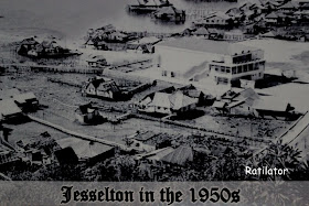
BANDAR JESSELTON DITUKAR NAMA KE KOTA KINABALU
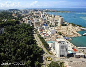
Pada hari ini dalam tahun 1967, nama ibu kota negeri Sabah telah ditukar daripada Jesselton kepada Kota Kinabalu. Kota Kinabalu terletak di Pantai Singgah Mata di Teluk Sepanggar. Nama baru itu mengambil ilham dari mercu tanda negeri Sabah, iaitu Gunung Kinabalu, merupakan gunung yang tertinggi di Malaysia dan di Asia Tenggara. Sebelum pekan di pantai Singgah Mata itu dijadikan pusat pentadbiran dan ibu kota negeri Sabah, beberapa tempat pernah menjadi ibu kota Kompeni Berpiagam. Antara ibu kota yang pertama ialah Kudat terletak di timur laut negeri itu dari tahun 1881 hingga 1883. Manakala pada tahun 1884 ibu kota itu telah dipindahkan ke Sandakan yang terletak di sebelah timur. Sandakan telah memainkan peranan sebagai bandar utama hingga tahun 1947. Kemudian pada tahun 1947, ibu kota Sabah sekali lagi telah berpindah ke Pantai Singgah Mata dengan nama Jesselton iaitu sempena nama pegawai Inggeris, Mr. Charles Jessel. Pegawai Inggeris, Charles Jessel telah memilih kawasan di Pantai Singgah Mata, ini sebagai ibu kota dan diberi nama Jessel Town (Jesselton). Pada hari ini dalam tahun 1967 nama Jesselton ditukar menjadi Kota Kinabalu. Sehingga ke hari ini Kota Kinabalu masih kekal sebagai ibu kota negeri Sabah dan menjadi lambang kemajuan dan kemakmuran Sabah.
Jika dilihat dari perpesktif sejarah Kota Kinabalu mempunyai sejarahnya sendiri yang bermula 100 tahun dahulu. Kota Kinabalu dikatakan bermula daripada perkampungan yang kecil yang dikenali sebagai Deasoka, kemudian bertukar kepada Singgah Mata dan diikuti dengan Api-api.
Jika dilihat aspek perkembangan Kota Kinabalu dapat dilihat kronologi pentadbiran daripada bandar sehinggalah perkembangan kepada dewan bandaraya. Perkembangan ini bermula daripada perwujudan lembaga kesihatan umum jesselton yang ditubuhkan dan merupakan salah satu bahagian pejabat daerah. Lembaga kesihatan umum Jeselton kemudiannya telah dipisahkan dengan pejabat daerah dan ditubuhkan sebuah lembaga bandaran jeselton dibawah ordinan perbandaran dan penguasa-penguasa bandar pada 1 julai 1954. Tanggungjawab utama Lembaga Bandaran Pada ketika itu adalah berkaitan dengan kebersihan bandar, perlesenan dan kutipan cukai tanah.
Pada akhir tahun 1800-an, Syarikat Borneo Utara British (BNBC) mula menubuhkan koloni di seluruh Borneo Utara (kini Sabah). Pada tahun 1882, Syarikat Borneo Utara British tersebut mengasaskan penempatan kecil di kawasan yang dikenali sebagai Teluk Gaya yang telah didiami oleh orang-orang Bajau. Penempatan pertama di Pulau Gaya (Pulau Gaya). Pada tahun 1897, penempatan pertama ini telah dibakar dan dimusnahkan oleh pejuang kebebasan asli Bajau yang diketuai oleh Mat Salleh.
Selepas pemberontakan tersebut, Syarikat Borneo Utara British telah memutuskan untuk memindahkan penempatan ke tanah besar dengan tujuan ia lebih mudah dipertahankan dan bertentangan dengan Pulau Gaya. Perkampungan nelayan yang berhampiran yang dinamakan Api-Api menjadi penempatan Syarikat Borneo Utara British yang baru. Lokasi baru ini kemudian ditetapkan sebagai pelabuhan utama serta perhentian untuk North Borneo Railway. Ia telah berkembang dan dinamakan semula sebagai Jesselton, dinamakan sempena Sir Charles Jessel, Naib Pengerusi Syarikat ketika itu.
"Jesselton telah dibakar oleh tentera British yang bakal berundur dalam Perang Dunia II untuk menghalang ia daripada jatuh ke tangan Jepun. Selepas Jepun mengambil alih Borneo, ia sekali lagi dinamakan Api.
Pada September 1967 nama jesselton telah ditukar kepada Kota Kinabalu. Berikutan daripada itu lembaga bandaran Jesselton telah menjadi lembaga bandaran Kota Kinabalu pada 22 disember 1967. Pada tahun 1979 Kota Kinabalu telah dinaikkan taraf daripada lembaga bandaran kepada Majlis perbandaran Kota Kinabalu di bawah Enakmen Kerajaan Tempatan 1978. Perubahan taraf Kota Kinabalu ini menyebabkan perkembangan pesat dalam kawasan Kota Kinabalu. Pada tahun 1984 Majlis Perbandaran Kota Kinabalu telah menyerap tugas dan tanggungjawab pejabat daerah Kota Kinabalu berikutan pembubaran pejabat daerah Kota Kinabalu pada 1 januari 1984
Kronologi pertumbuhan penduduk bagi bandaraya kota kinabalu juga sangat jelas dilihat. Pada tahun 1960 jimlah penduduk di kota kinabalu adalah 21 719 orang. Jumlah ini meningkat kepada 40939 pada tahun 1980. Jumlah ini terus meningkat pada 1980 kepada 83800 orang. Data terbaru pula adalah pada tahun adalah 452 058 orang.
Sir Charles Jessel, Naib Pengerusi SBUB pada ketika itu, nama Jesselton diambil dari nama beliau.
Sir Charles Jessel dua dari kiri (Gambar ahli lembaga pengarah North Borneo Company (NBUB))
Jesselton dalam tahun 1940an selepas perang dunia pertama
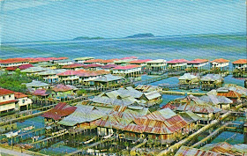
Gambar poskad Kampung Ayer Keroh di Jesselton pada 1967
Hari ini 26/12/2015 The Great Earthquake of 26 December 2004 in Southeast Asia and Indian Ocean
On Sunday, 26 December 2004, the greatest earthquake in 40 years occurred about 150 kilometers off the west coast of northern Sumatra Island in Indonesia. The earthquake generated a disastrous tsunami that caused destruction in 11 countries bordering the Indian Ocean.
A powerful earthquake off the coast of Sumatra, Indonesia, on this day in 2004 sets off a tsunami that wreaks death and devastation across the Indian Ocean coastline. The quake was the second strongest ever recorded and the estimated 230,000 dead made this disaster one of the 10 worst of all time.
It was 7:58 a.m. when the tremendous quake struck beneath the Indian Ocean 160 miles west of Sumatra. Not only did it register at approximately a 9.3 magnitude (only the 1960 Chile earthquake measured higher at 9.5, though there may have been stronger tremors prior to the invention of seismographic equipment) and last nearly 10 minutes, the quake moved a full 750 miles of underwater fault line earth up to 40 feet. The movement of the earth–there is evidence that huge boulders weighing thousands of tons were pushed several miles along the ocean floor–caused a massive displacement of water. It is estimated that the resulting tsunami had two times the energy of all the bombs used during World War II.
Within 15 minutes, tsunami waves were crashing the coast of Sumatra. At the north end of the island was a heavily populated region known as Aceh. There, waves reached 80 feet high over large stretches of the coast and up to 100 feet in some places. Entire communities were simply swept away by the water in a matter of minutes. The death toll in Indonesia is estimated at between 130,000 and 160,000 people, with an additional 500,000 people left homeless. About a third of the victims were children.
The huge waves missed the coast of Indonesia on the north side and went on to Thailand, where between 5,000 and 8,000 people died. The tsunami also moved east across the Indian Ocean. In Sri Lanka, the tsunami came ashore about 90 minutes after the earthquake. Although the waves were not as high as in Aceh, they still brought disaster. Approximately 35,000 people lost their lives and half a million others lost their homes. In addition, about 15,000 people died in India. The killer waves even reached 5,000 miles away in South Africa, where two people perished.
In total, about 190,000 people are confirmed dead with another 40,000 to 45,000 missing and presumed dead. Although billions of dollars of humanitarian aid poured in to the affected region in the aftermath of the disaster–an estimated $7 billion within the first 18 months—some areas are still suffering from the massive devastation.
One year prior to this earthquake and tsunami, almost to the hour, a 6.6-magnitude quake rocked Bam, Iran, killing 30,000 people.
Origin Time and Epicenter
The great tsunamigenic earthquake occurred on Sunday, 26 December 2004, at 00:58:50 UTC (6:58:50 a.m. local time). The epicenter was at 3.298 N, 95.779 E and its focal depth was very shallow (much less than 33 km - possibly about 10km)
Magnitude and Energy Release
The quake was widely felt in Sumatra, the Nicobar and Andaman Islands, Malaysia, Myanmar, Singapore, Thailand, Bangladesh and India.
According to the U.S. Geological Survey (USGS NEIC (WDCS-D)), the moment magnitude of the earthquake - which is larger than the Richter magnitude - was 9. Such magnitude would make this earthquake to be the fourth largest in the world since 1900 - and the largest since the 1964 Alaska earthquake.
However, on the basis of subsequent analysis of additional seismograms from around the world, scientists at Northwestern University determined the earthquake's magnitude to be 9.3 and not 9.0, as originally estimated. Therefore, the calculated energy release was 1.13 X 10 (raised to the 30 power) dynes-cm , or three times larger than originally thought. The revised estimate makes this earthquake to be the second largest ever instrumentally recorded. The largest earthquake ever recorded, which measured 9.5, was in Chile on May 22, 1960.
USGS graphic showing the migration of the Indian tectonic plate
Tectonic Setting
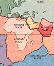
The region where the great earthquake occurred on 26 December 2004, marks the seismic boundary formed by the movement of the Indo-Australian plate as it collides with the Burma subplate, which is part of the Eurasian plate. However, the Indo-Australian tectonic plate may not be as coherent as previously believed. According to recent studies reported in the Earth and Planetary Science Letters (vol 133), it apears that the two plates have separated many million years ago and that the Australian plate is rotating in a counterclockwise direction, putting stress in the southern segment of the India plate.
For millions of years the India tectonic plate has drifted and moved in a north/northeast direction, colliding with the Eurasian tectonic plate and forming the Himalayan mountains. As a result of such migration and collision with both the Eurasian and the Australian tectonic plates, the Indian plate's eastern boundary is a diffuse zone of seismicity and deformation, characterized by extensive faulting and numerous large earthquakes.
The epicenter of the 26 December 2004 earthquake was near the triple point junction of three tectonic plates where major earthquakes and tsunamis have occurred in the past.
Previous major earthquakes have occurred further north, in the Andaman Sea and further South along the Sumatra, Java and Sunda sections of one of the earth's greatest fault zones, a subduction zone known as the Sunda Trench. This great trench extends for about 3,400 miles (5,500 kms) from Myanmar (Burma) south past Sumatra and Java and east toward Australia and the Lesser Sunda Islands, ending up near Timor. Slippage and plate subduction make this region highly seismic. The volcanoes of Krakatau, Tambora and Toba, well known for their violent eruptions, are byproducts of such tectonic interactions.
In addition to the Sunda Trench, the Sumatra fault is responsible for seismic activity on the Island of Sumatra. This is a strike-slip type of fault which extends along the entire length of the island.
The Burma plate encompasses the northwest portion of the island of Sumatra as well as the Andaman and the Nicobar Islands, which separate the Andaman Sea from the Indian Ocean. Further to the east, a divergent boundary separates the Burma plate from the Sunda plate.
More specifically, in the region off the west coast of northern Sumatra, the India plate is moving in a northeastward direction at about 5 to 5.5 cm per year relative to the Burma
plate.
Tsunami Wave Heights and Tsunami Travel Times
Tsunami waves varied in height. Maximum reported height was reported as being 10.5 meters, A detailed report on tsunami wave distribution for different of the stricken areas througout the Indian Ocean is being compiled from reports of eyewitnesses and other sources. A list of tsunami wave heigts as recorded by tide stations will be provided. However, most of the tide stations that recorded the tsunami are at distant locations. It is not known at this time whether any tide gauge stations closer to the tsunami generating area recorded the tsunami. An effort is being made to locate such records from tide stations that were not destroyed by the tsunami - if such stations exist,
Tsunami travel times for different areas in the Bay of Bengal and throughout the Indian Ocean are being compiled. Travel times of the first tsunami wave after the earthquake: Sumatra 10 minutes ,Thailand: 1 Hour, Sri Lanka: 2 hours, India: 2 Hours, East Africa: about 7 Hours.
Three-dimensional computer-generated graphic of the seabed in the vicinity of the recent earthquake in Southeast Asia.
(Picture / Reuters, Royal Navy vessel HMS Scott(9 Feb 2005)
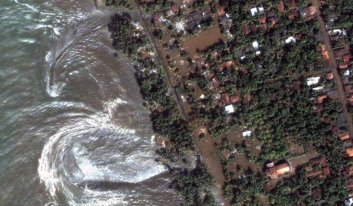
Satellite Image of Banda Aceh taken on 2 Jan 2005
Peninsula of Acep Meulaboh in Northern Sumatra - one of the hardest hit by the tsunami areas.
11 facts about the earthquake and tsunami:
The December 26, 2004 Indian Ocean tsunami was caused by an earthquake that is thought to have had the energy of 23,000 Hiroshima-type atomic bombs.
The epicenter of the 9.0 magnitude quake was located in the Indian Ocean near the west coast of Sumatra.
The violent movement of the Earth’s tectonic plates displaced an enormous amount of water, sending powerful shock waves in every direction.
The tectonic plates in this area had been pushing against each other and building pressure for thousands of years. They continue to do so and will likely cause underwater earthquakes and tsunamis in the future.
The rupture was more than 600 miles long, displacing the seafloor by 10 yards horizontally and several yards vertically. As a result, trillions of tons of rock moved, causing the largest magnitude earthquake in 40 years.
Within hours of the earthquake, killer waves radiating from the epicenter slammed into the coastlines of 11 countries, damaging countries from east Africa to Thailand.
A tsunami is a series of waves - the first wave may not be the most dangerous. A tsunami “wave train” may come in surges five minutes to an hour apart. The cycle is marked by the repeated retreat and advance of the ocean.
Despite a lag of up to several hours between the earthquake and the impact of the tsunami, nearly all of the victims were taken completely by surprise because there were no tsunami warning systems in place.
The Indian Ocean tsunami traveled as far as 3,000 miles to Africa and still arrived with sufficient force to kill people and destroy property.
Many people in Indonesia reported that they saw animals fleeing for high ground minutes before the tsunami arrived – very few animal bodies were found afterward.
The tsunami resulted in at least 227,898 fatalities.
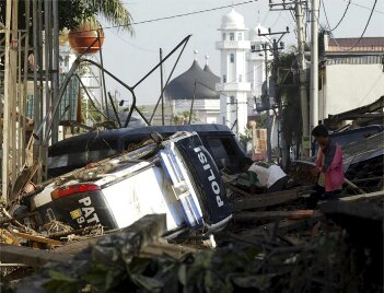
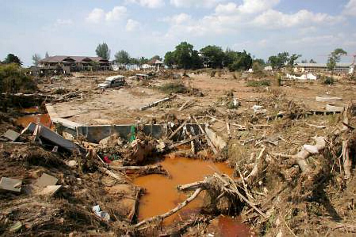
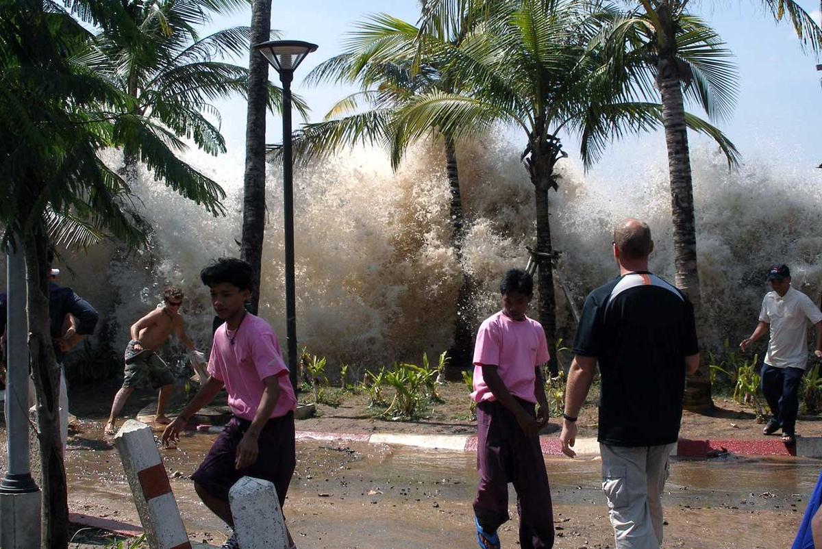
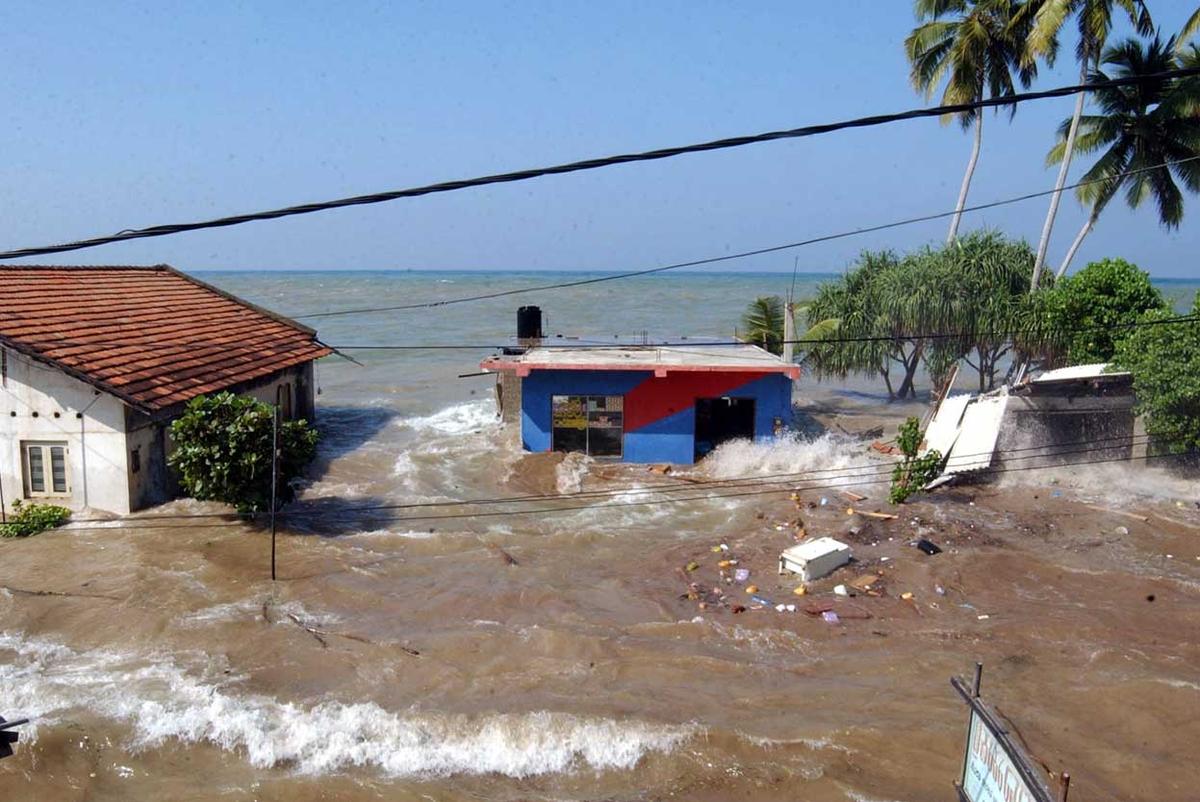
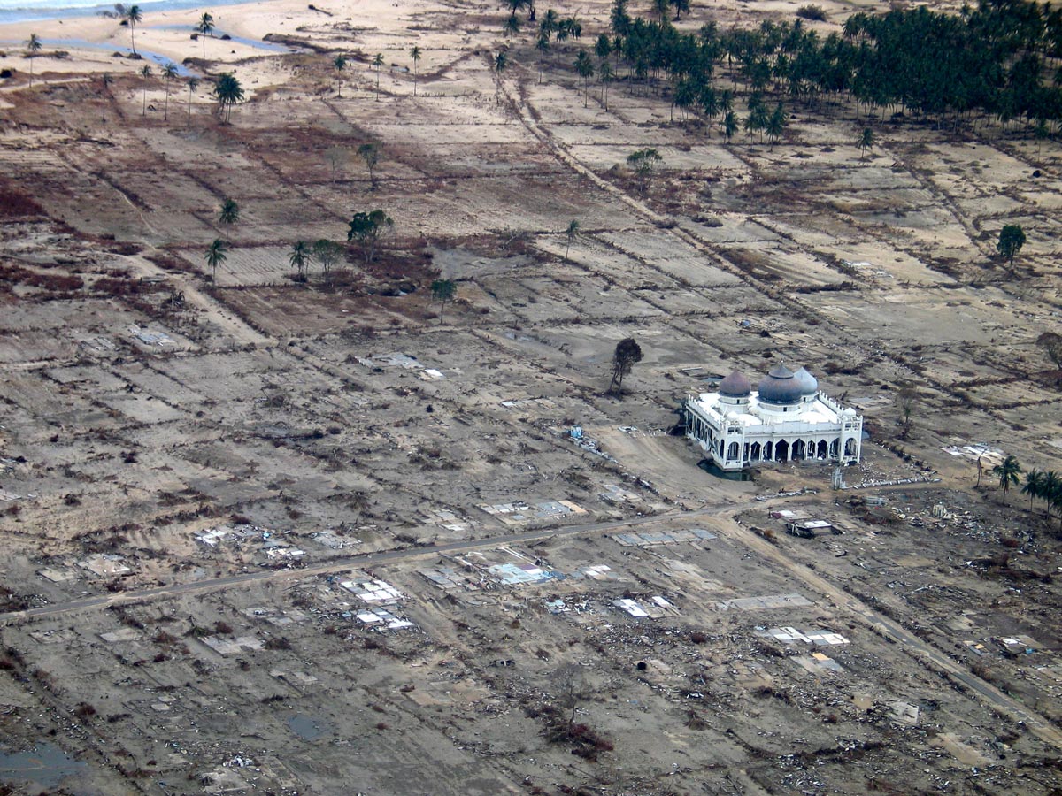
Some photos after the disaster
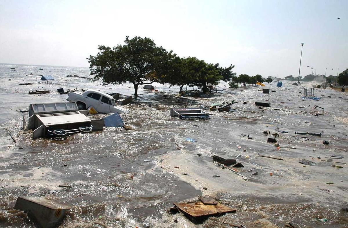
After the disaster in Banda Acheh aftereffect in Khao Lak Beach, Thailand Seawater splashes in the air as the the first tsunami waves hit Ao Nang, Krabi Province, Thailand,
Waves wash through houses at Maddampegama, about 60 kilometers (38 miles) south of Colombo, Sri Lanka. Tsunami waves triggered by earthquakes crashed into villages along a wide stretch of Sri Lankan coast, killing more than 35,300 people and displacing millions
A natural color satellite image shows the coastline of the southwestern city of Kalutara, Sri Lanka on December 26, 2004 at 10:20 a.m. local time, slightly less than four hours after the 6:28 a.m. (local Sri Lanka time) earthquake and shortly after the moment of tsunami impact
A general view of the scene at Marina beach in Madras, India, on December 26, 2004, after tsunami waves hit the region. Waves devastated the southern Indian coastline killing an estimated 18,000 people
Hari ini dalam sejarah, 30 Disember 1896. Novelist Filipina dihukum bunuh.
Jose Rizal
Full Name: Jose Rizal
Nationality: Filipino
Profession: Filipino Nationalist and Novelist
Why Famous: Rizal, is remembered as great hero and the voice of the Filipino people during colonization by the Spaniards in the late 19th century. He fought for peaceful reforms through his writings while exposing the ills that beset the country.
A prolific writer, he wrote his novels "Noli Me Tangere" and "El Filibusterismo" to expose the ills of Philippine society; government corruption, abuse; and on a larger scale, the effects of colonization on people's lives.
Rizal was arrested and convicted on charges of rebellion, sedition, and conspiracy that lead his execution in 1896. Now revered as a national hero Rizal's novels are standard texts in Filipino schools.
Born: 19th June, 1861
Star Sign: Gemini
Birthplace: Calamba City, Laguna, Philippines
Died: 30th December, 1896 (aged 35)
Cause of Death: Execution by firing squad
Married Life
1896-12-30 - Filipino Nationalist Jose Rizal (35) weds girlfriend Josephine Bracken (20) before his execution in Fort Santiago, Manila
Historical Events in the Life of Jose Rizal
1892-07-06 - Jose Rizal forms La Liga Filipina in Manila
1896-10-06 - Filipino nationalist Jose Rizal is arrested en route to Cuba via Spain and imprisoned in Barcelona
1896-12-30 - Filipino nationalist José Rizal is executed by firing squad in Manila by the Spanish.
aku tak berapa setuju lah undang2 nih , menyebabkan umat islam terkejar2 waktu subuh dengan masa untuk masuk kerja, terutamanya guru dan anak2 sekolah.itu pendapat aku le..bukan boleh ubah pon.
Post time 11-1-2016 04:09 PMFrom the mobile phone|Show all posts
nize replied at 11-1-2016 03:45 PM
aku tak berapa setuju lah undang2 nih , menyebabkan umat islam terkejar2 waktu subuh dengan masa u ...
Kt kelantan dah buat jadual sklh baru start pukul 8pg. X sure plk utk start tahun 2016 ke 2017. Tp utk sekolah YIK aje lah..sklh kementerian tetap sama waktu pertama kelas tu.
Sokong sgt idea ubah waktu mula kerja kerja atau sklh kan? Xde la terkejar2.
ntah .. kata nak mengimarohkan masjid waktu subuh berjamaah , siap ada bagi breakfast skali kat beberapa masjid area putrajaya namun tanpa menganjakkan waktu masuk kerja /sekolah jamaah reluctant utk dtg sbb terkocoh kocoh untuk g kerja.
1. 1533 - England's King Henry VIII secretly marries his second wife, Anne Boleyn. Boleyn later gave birth to Elizabeth I
2. 1915 - Alexander Graham Bell inaugurates a transcontinental telephone service.
3. 1924 - The first Winter Olympics games takes place in the French Alps
4. 1938 - Etta James is born
5. 1942 - Thailand declares war on the United States, England, and other World War II allied forces
6. 1947 - Al Capone dies of pneumonia and heart failure, after fearing all his life he would suffer a gangsters death.
7. 1964 - The Beatles get their first US number one with I Want To Hold Your Hand
8. 1971 - Charles Manson is convicted, along with his Cult followers Susan Atkins, Leslie Van Houten, and Patricia Krenwinkle, of the brutal 1969 murders of actress Sharon Tate and six others
9. 1985 - Russia prepares to launch a nuclear attack, following a Norwegian launch of a Black Brant XII four-stage sounding rocket to study the aurora borealis over Svalbard
10. 1995 - The defense gives its opening statement in the O.J. Simpson trial
11. 1999 - Six members of the International Olympic Committee face expulsion following an inquiry into a corruption scandal
Pada hari ini 12 Mac 624M bersamaan 17 Ramadhan 2H berlaku perperangan bersejarah dalam Islam iaitu Perang Badar (Bahasa Arab: غزوة بدر), di Hijaz (Koordinat: 23°44′N 38°46′E), di bahagian barat Semenanjung Arab (kini Arab Saudi).
Pasukan kecil kaum Muslim yang berjumlah 313 orang bertempur menghadapi pasukan kafir Quraisy dari Mekkah yang berjumlah 1,000 orang. Setelah bertempur habis-habisan sekitar dua jam, pasukan Muslim menghancurkan barisan pertahanan pasukan kafir Quraisy, yang kemudian berundur dalam kekacauan.
Ia pertempuran penting dalam zaman awal Islam dan merupakan titik perubahan dalam perjuangan Nabi Muhammad s.a.w. dengan pihak kafir Quraisy di Makkah.
Pertempuran ini telah dilakarkan dalam sejarah Islam sebagai kemenangan muktamad sebagaimana yang terdapat dalam Quran dan hadis Nabi Muhammad s.a.w.
Sebelum pertempuran tersebut, telah berlaku beberapa pertempuran kecil antara pihak Muslim dan kafir Quraisy pada lewat tahun 623M dan awal tahun 624M, walau bagaimanapun Perang Badar merupakan pertempuran skala besar pertama antara kedua pihak.
Selepas mara ke kedudukan pertahanan, sahabat Nabi Muhammad s.a.w yang penuh keimanan dan berdisiplin tinggi berjaya memecahkan barisan puak kafir Makkah dan membunuh beberapa ketua Quraisy termasuk satu daripada musuh utama Islam, iaitu Amru bin Hisham (Abu Jahal).
14 orang sahabat Nabi s.a.w syahid dalam Perangan Badar.
50 hingga 70 orang kematian dikalangan kafir Quraisy dan 43 hingga 70 orang kafir Quraisy menjadi tawanan.
Post time 18-4-2016 07:59 PMFrom the mobile phone|Show all posts
SEJARAH HARI INI (18 APRIL): AWAL MULA KISAH SUKSES REAL MADRID
Eric Noveanto
00:01SEJARAH HARI INIBAGIKAN
3 Getty Images
Los Blancos sukses menjadi kampiun Cope del Rey untuk kali pertama pada tahun 1905, yang merupakan awal mula kisah sukses mereka hingga saat ini.
GOAL OLEH ERIC NOVEANTO Ikuti di twitter
Kemenangan 1-0 yang dibukukan Real Madrid atas Athletic Bilbao pada 18 April 1905 silam dalam ajang Copa de Su Majestad El Rey Alfonso XIII atau yang kini dikenal dengan Copa del Rey, memiliki tempat tersendiri dalam catatan sejarah klub.
Ya, Los Blancos berhasil menjadi kampiun dalam turnamen tersebut, trofi pertama yang diraih dua tahun sejak bedririnya klub merupakan penanda awal dalam kisah sukses klub yang hingga sejauh ini mampu meraih banyak gelar bergengsi.
Lima tim ambil bagian dalam turnamen yang digelar pertama kali pada 1902 termasuk rival abadi mereka, Barcelona yang mencatatkan duel El Clasico untuk kali pertama dalam babak semi-final turnamen pada 14 Mei tahun tersebut, dengan raksasa Catalunya memetik kemenangan 3-1.
Hello everyone! maymost.co/
- We are a company manufacturing and Wholesale jewelry, high-quality counterfeit products, low prices, and brand logo,wholesale discounts, if you want to do part-time, go to our online wholesale mall - maymost.co/.
World famous brands replica Van Cleef & Arpels jewelry, replica Cartier jewelry, Hermes, etc.
If you have any ideas, please contact us, thank you! Email: sales@lightwithme.com.
PULAU TIGA DI ISTIHARKAN SEBAGAI TAMAN NEGARA DI SABAH
Pada hari ini 26.7.1978, Pulau Tiga telah diisytiharkan oleh kerajaan negeri Sabah sebagai Taman Negara Yang keempat di Sabah. Taman Negara Pulau Tiga yang terletak di Teluk Kimanis di Laut Cina Selatan ini, meliputi kawasan seluas 15,863.85 hektar di mana 607.035 hektar meliputi kawasan tanah daratan Pulau tiga, Pulau Kalampunian Damit dan Pulau Kalumpunian Besar. Kawasan selebihnya, iaitu kira-kira 15,256.813 hektar meliputi kawasan perairan dan terumbu karang di sekeliling pulau tersebut.
Tujuan utama pengisytiharan taman negara ini ialah :-
1.Melindungi dan memelihara kawasan hutan, tumbuh-tumbuhan pinggir laut, rumpai dan terumbu karang, ikan, lanar gunung berapi dan fauna di pulau ini dari tercemar.
2.Membanyakkan lagi kawasan-kawasan rekreasi yang lengkap dengan berbagai-bagai kemudahan untuk tujuan pelancongan.
Diharap dengan kemudahan-kemudahan yang disediakan di Taman Negara tersebut seperti kawasan untuk berenang, berperahu, memancing, mengembara, berkelah dan mengkaji tumbuhan-tumbuhan, akan dapat menarik lebih ramai pengunjung ke pulau ini, di samping menikmati keindahan alam semulajadinya.


 Post time 11-12-2015 05:05 PM
 Dato' Seri Syed Razak dilantik sebagaiMenteri Besar Kedah ke-8 menggantikan Tan Sri Dato' Seri Sanusi Junid pada 12 Disember 1999 sehingga 2005. Sebagai Menteri Besar Kedah pada masa itu beliau bertanggungjawab ke atas kewangan dan belanjawan negeri, bertindak sebagai Pengerusi Jawatankuasa Galakan Pelaburan, Jawatankuasa Perancang Ekonomi Negeri, Jawatankuasa Perancang Negeri, Majlis Pembangunan Negeri, Jawatankuasa Tanah dan Hasil Bumi, Jawatankuasa Pembangunan Teknologi Maklumat dan Jawatankuasa Keselamatan Negeri.


 Post time 21-12-2015 06:56 PM


![[JTBC/Netflix 2024] FRANKLY SPEAKING/NO SECRET ~ Go Kyoung Pyo, Kang Han Na, Joo Jong Hyuk](https://uf.cari.com.my/forumx/mforum/block/4e/4e9f8892d4649e51242f87a8a479e998.jpg)
![[Disney+ 2023] MOVING - Ryu Seung Ryong, Han Hyo Joo, Jo In Sung, Cha Tae Hyun, Kim Sung Kyun](https://uf.cari.com.my/forumx/mforum/block/91/9169b461ef6e76f7ea9cb879fd0f2816.jpg)
![[VIDEO] Pokok tumbang hempap landasan monorel, kereta di Jalan Sultan Ismail. ...](https://uf.cari.com.my/forumx/mforum/block/3c/3c7624e2fec33ec9f747329af2294ed4.jpg)


